Section K: Channel & Bank Features
SECTION K: EXTENT OF CHANNEL AND BANK FEATURES
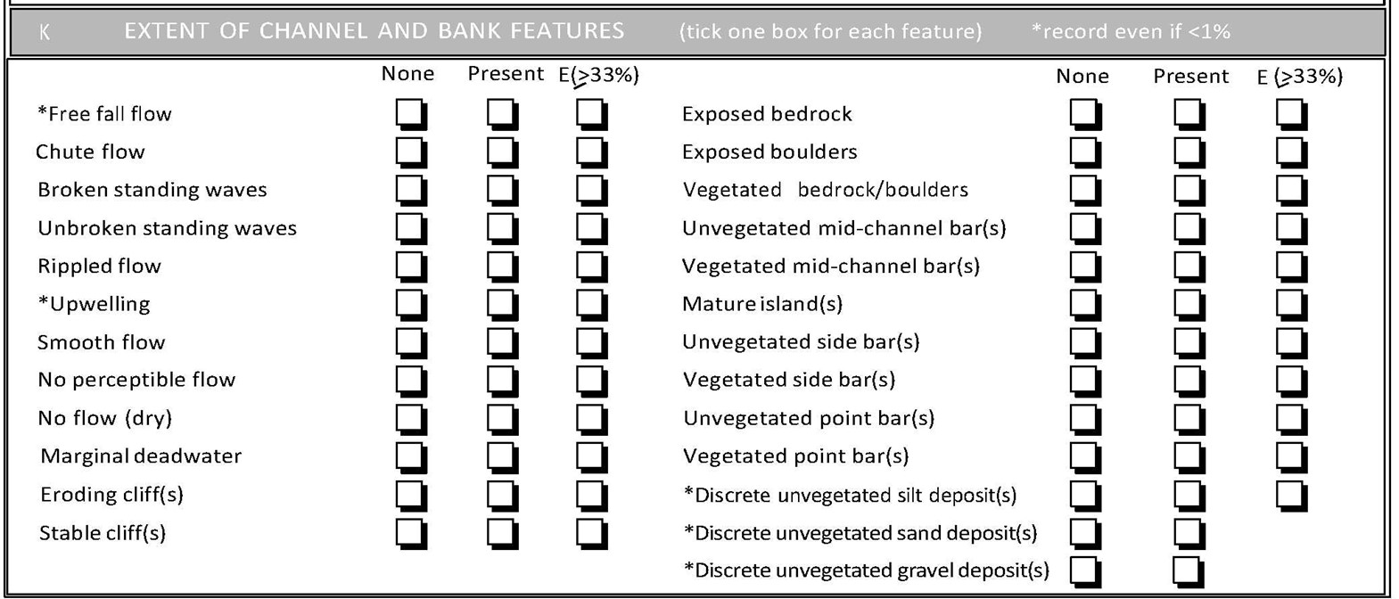
This section includes a wide variety of features ranging from bars to exposed bedrock. In each case, one box per feature must be ticked.
Records are made on their occurrence within, or along, the total 500m length of the site. Record ‘None’ when <1% occurrence; ‘Present’ if 1-33% occurrence; and ‘E’ when >= 33% occurrence. For the five features marked with an asterisk (*), presence can be ticked even if they do not occur in >1% of the site.
For the definitions of channel features, see Section E. The following are recorded (spot-check abbreviations are included for easy cross-reference).
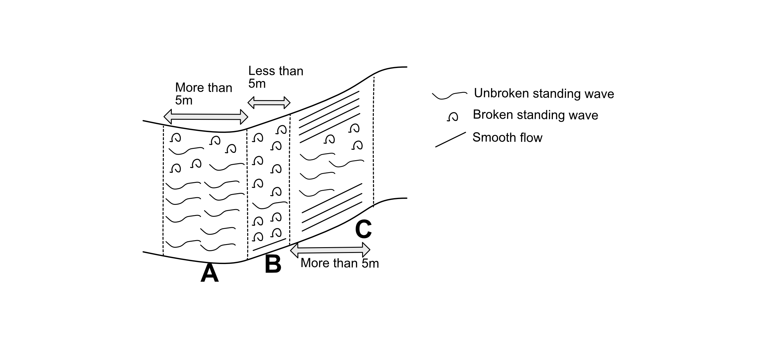
RHS uses flow-types as a diagnostic guide to channel habitats. Predominant flow-type is determined at the 10 spot-checks (Section E). However, it is also necessary to assess flow-types in the site as a whole. For this purpose only, you need to record flow-types when they are dominant across most of the channel width and when they form a distinct feature that is at least 5m long (i.e. >1% of channel length). This is illustrated In the graphic below, three flow types (unbroken standing wave, broken standing wave and smooth flow) are mapped from a reach of a river. The reach has been split into arbitary sections (dotted lines) separating major flow type areas.
- Section A would lead to unbroken standing waves being marked as (at least) present because this flow type forms the majority of the flow type across the river width in this section and the section is more than 5m in length.
- Section B has a majority of broken standing waves across the width of the river but is not listed as present because the section is less than 5m long.
- Section C has smooth flow marked as at least present as this flow type forms the majority of the flow type across the river width in this section and the section is more than 5m in length.
‘Free fall’ and ‘upwelling’ flow-types can be recorded as present even if they do not represent a predominant flow type along at least 5m of the channel length. Do not record these flow-types in Section K if they result from artificial features such as weirs.
For the definitions of flow-types and channel features, see Section E. The following are recorded (spot-check abbreviations are included for easy cross-reference).
- *Free fall flow (FF) – but only if associated with natural features
- Chute flow (CH)
- Broken standing waves (BW)
- Unbroken standing waves (UW)
- Rippled flow (RP)
- *Upwelling (UP) - but only if associated with natural features
- Smooth flow (SM)
- No perceptible flow (NP)
- No flow [dry] (DR)
The following other (non-flow-type related) features are also recorded.
Marginal deadwater
Margins of the main channel which have no perceptible flow. These are good refuge areas for various aquatic invertebrates and fish fry. Examples include where the bank has eroded into an embayment, or remnants of old abandoned channels are still connected to the main channel (also recorded as backwaters in Section M). Marginal deadwater may also occur downstream of large ‘side bars’.
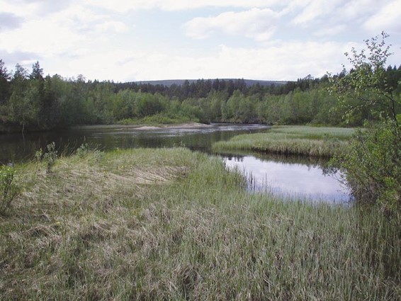
Examples of Marginal Deadwaters
Unvegetated earth cliff(s)
See Section E, marginal and bank features. Extent is for both banks.
Vegetated earth cliff(s)
See Section E, marginal and bank features. Extent is for both banks.
Exposed bedrock
See Section E, channel features.
Exposed boulders
See Section E, channel features.
Vegetated bedrock/boulders
See Section E, channel features.
Unvegetated mid-channel bar(s)
See Section E, channel features.
Vegetated mid-channel bar(s)
See Section E, channel features.
Mature island(s)
See Section E, channel features.
Unvegetated side bar(s)
See Section E, marginal and bank features. Extent is for both banks.
Vegetated side bar(s)
See Section E, marginal and bank features. Extent is for both banks.
*Discrete unvegetated silt deposit(s)
DO NOT RECORD when silt covers the bed from bank to bank and does not contrast with the predominant substrate present in the whole site (recorded as ‘SI’ in spot-checks in Section E) – the deposits must contrast with the predominant river bed substrate(s). Unvegetated silt deposits may be either underwater or exposed, in the channel or on the margins with a minimum size of 5m2. Silt deposits are often formed in response to obstructions (e.g. fallen tree, naturally protruding boulders, or artificial deflector structures); such deposits would be recorded as ‘present’. Extensive deposits are often associated with rivers recovering from artificial channel over-widening. If they form discrete ledges, and occur in more than 33% of the site, record as ‘E’.
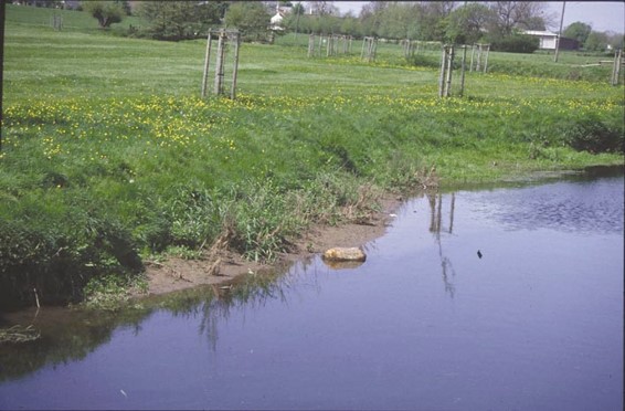
Example of Discrete, Unvegetated Silt Deposit
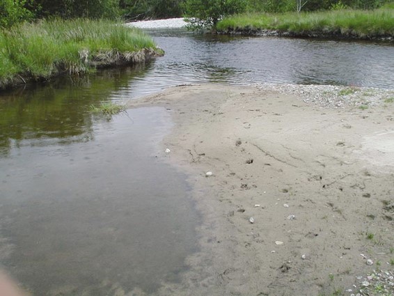
*Discrete unvegetated sand deposit(s)
A discrete unvegetated sand deposit is either underwater or exposed, in the channel or on the margins with a minimum size of 5m2. DO NOT RECORD when sand covers the bed from bank to bank (recorded as ‘SA’ in Section E) – the deposits must contrast with the predominant river bed substrate(s). Discrete sand deposits are often formed in response to obstructions (e.g. fallen tree, naturally protruding boulders or artificial deflector structures), or in recesses in banks. Discrete sand deposits are recorded because they are valuable habitats for several invertebrate species. As sand deposits are not considered to be ‘discrete’ if they are present along more than 33% of a site (sand would be a predominant substrate in Section E), it is not possible to record extensive discrete sand deposits (‘extensive’ box not on the form).
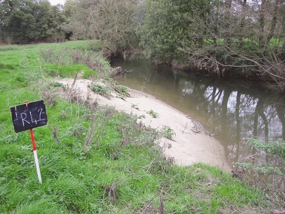
Example of Discrete Sand Deposit
Silt over gravel
If silt is present across the site as a thin layer over or inside gravel-cobble bed (you can check by kicking the gravel bed and checking for silt plumes), record it as ‘Silt over gravel’. Silt over or inside gravel and cobble beds can be detrimental to species living or laying their eggs in the substrate.