Marginal & Bank Features
SECTION E: PHYSICAL ATTRIBUTES – MARGINAL AND BANK FEATURE(S)
Recording relates purely to ‘cliffs’ (bank features), and ‘bars’ (depositional marginal features). Boxes are NOT emboldened, so more than one entry per box is permissible.
Not visible (NV)
Self-explanatory. Use for culverts and if the far bank and margin are obscured by large mid-channel structures or impenetrable vegetation. Beware overgrown channels in late summer where vegetation may also mask features.
None (NO)
No obvious features. Record only when there is a clear view of the bank and marginal areas of the spot- check, AND no features are present.
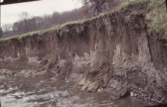
Eroding cliff (EC)
Bankface profile is predominantly vertical, near vertical, or undercut, with a minimum height of 0.5m, and showing a ‘clean’ face (<50% cover of mosses, ferns and other vegetation). The angle of the cliff will depend on bank substrate; clay or cohesive earth banks are often almost vertical; sandy ones are rarely this steep. Other clues: turf overhanging cliff, turf in channel, recently fallen trees, leaning or over-hanging fence posts.
If eroding cliff is composed of sandy soil, sands and/or gravel, put circle around EC
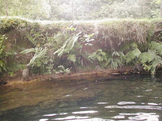
Vegetated stable cliff (SC)
Bankface profile is predominantly vertical, near vertical, or undercut, with a minimum height of 0.5m, and without obvious signs of recent erosion. Mosses, ferns and other vegetation on the bankface usually cover >50% of the bankface. Some clay banks may have little or no vegetation, but are nevertheless stable.
Vertical rock faces should not be recorded as ‘SC’. The purpose of recording ‘cliffs’ is to identify the instream sources and character of sediments that may be transported downstream, and those riverine features associated with active erosion.
Bars
Bars are depositional features, primarily composed of material transported down the river channel, and deposited on the river bed. River bed material can be carried long distances (many kilometres), or very short distances, depending on the size of the material and the energy of the river. A gravel-bed river will usually have gravel bars; a sand-bed river will have sand bars.
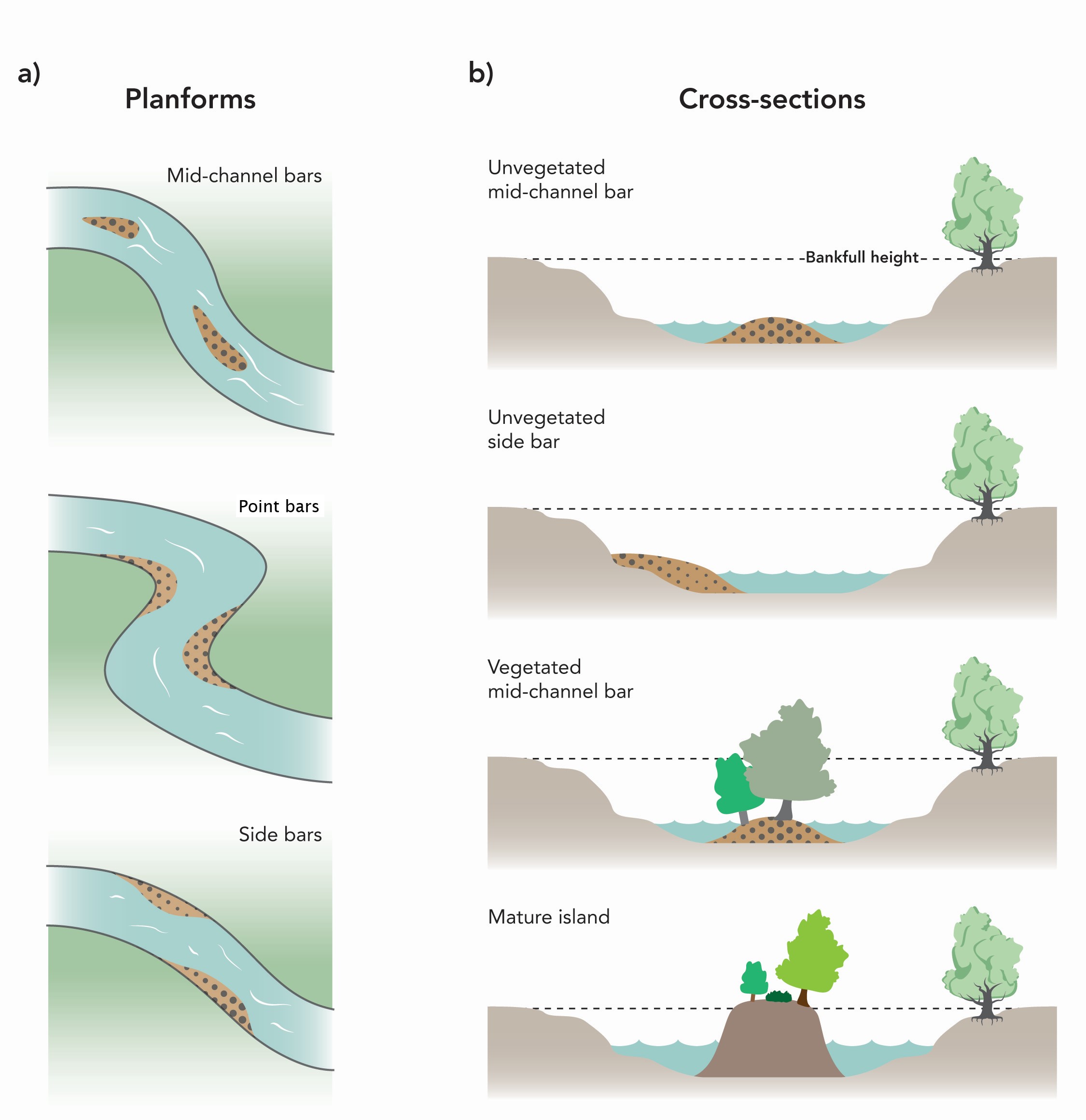
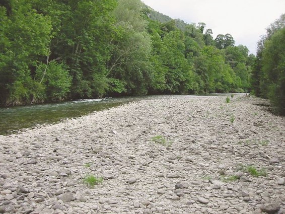
Unvegetated point bar (PB)
A distinctive depositional feature composed of unconsolidated river bed material. Exposed at low flow, usually with a shallow slope into the water. Characteristically located on the inside of a distinct meander bend in actively eroding/depositing rivers. Classified as ‘unvegetated’ if <50% of the surface area has plant cover.
Constituent material of point bars is primarily sediment that has been transported from upstream; it is generally not derived locally. This contrasts with slumped banks recorded in Section I.
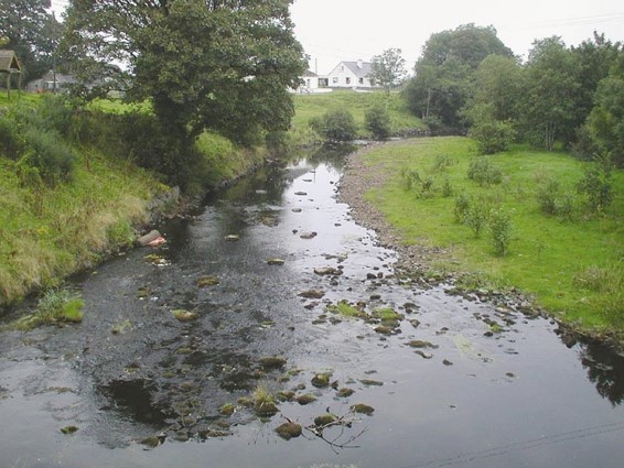
Vegetated point bar (VP)
A distinctive depositional feature composed of consolidating river bed material. Exposed at low flow, usually with a shallow slope into the water. Characteristically located on the inside of distinct meander bends, usually on reaches of rivers that are less-active than where ‘unvegetated’ bars are found. Constituent material comprising the bars is as for unvegetated point bars. Classified as ‘vegetated’ if >50% of surface area has plant cover, often showing a successional sequence from bare shingle to scrub, and may include mosses.
Constituent material comprising teh bars is as for unvegetated point bars.
Unvegetated side bar (SB)
A distinctive depositional feature composed of unconsolidated sediment located along the margins of rivers. Exposed at low flow, usually with a shallow slope into the water. ‘Unvegetated’ when <50% of the total surface area has plant cover.
Found in locations other than the inside of distinct bends. Material similar to that described for unvegetated point bars.
Vegetated side bar (VS)
A distinctive depositional feature composed of consolidating sediment along the margins of rivers. Exposed at low flow, usually with a shallow slope into the water. ‘Vegetated’ when >=50% of the total surface area has plant cover. May show a successional sequence from bare shingle, herbs and mosses, to scrub. Material similar to that described for unvegetated point bars.
Point or side bars composed of silt are extremely unlikely to occur in UK rivers. Silt is not considered to be a substrate of distinct ‘bars’; if silt is the predominant substrate in spot-checks, record SI; if discrete silt deposits are present record these as ‘present’ in Section K, and if large expanses of silt occur record as ‘extensive’ in Section K. If the silt forms distinct deposits resembling bars, note this in Section P, as these deposits are often signs of channels recovering from over-widening as a result of engineering works.
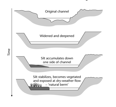
Over time, some continuous silt deposits along river margins may become stable, and resemble ‘bars’. When they become vegetated and have accreted sufficient sediment to be exposed during dry-weather flow, they should be recorded as ‘natural berms’. If in doubt, take a photograph.
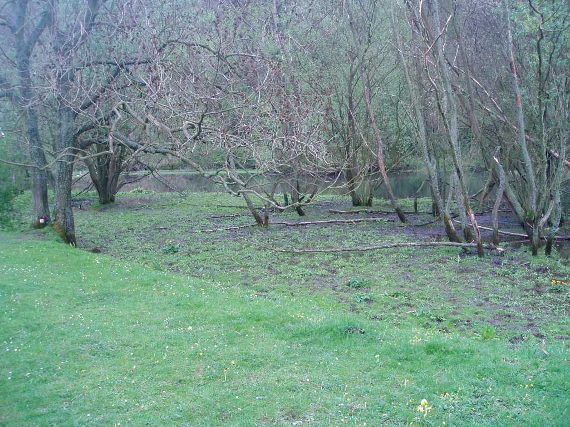
Natural berm (NB)
A relatively rare feature that is transitional between a depositional bar and a terrace on the floodplain. Not to be confused with an artificial berm (see definition and check against river management records. Natural berms can occur in: (i) actively meandering channels; or (ii) recovering rivers naturally restoring a low-flow channel width following over-widening. They can also occur as a transitional feature if channel straightening downstream results in downcutting and channel narrowing produces increased gradient.
To qualify as a natural berm, the profile must have a marked step, or a composite profile with ridges representing a series of deposition/incision events. Natural berms develop through deposition (or incision) processes and over time often attract further sediment deposition. If formed on the inside of a meander they may also have a point bar features at the water’s edge. They are usually vegetated, making them relatively stable and attracting further deposition. Depending on location and age, the vegetation may comprise bankside herbs, grasses and reeds, or a mixture of these with willow and alder saplings. As ‘mature bank or riparian’ vegetation becomes established, and the berm becomes higher in relation to the river bed (either by channel down-cutting or further deposition on the berm), old berms then become the new ‘bankface’ and ‘banktop’. Natural berms do not develop from bank erosion features such as slumping/slips.
Natural berms are difficult to determine precisely, and when recorded, should be photographed for subsequent confirmation.
Sequence of natural berm and terrace formation
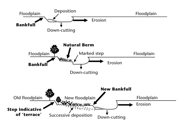
Formation of natural berm following recovery from channel over-widening