Section A: Survey Details
SECTION A: Field Survey Details
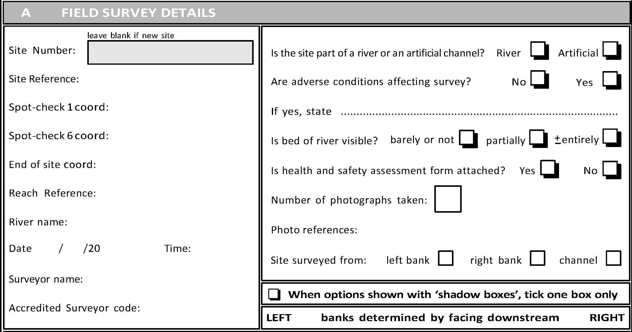
Site number
For RHS database entry purposes only. Every site will be given a unique reference number when entered on the RHS database. Leave blank if new site. For re-surveyed sites, enter original number (if known) followed by (R) to indicate repeat survey.
Site reference
Surveyors should enter their own unique reference number/name for the site, and replicate it on the left hand corner on each page of the form. Try to make the site reference unique so that you can easily identify it. Photos should also contain the site reference. The RHS Toolbox will generate a unique site number following data entry and upload to the online data repository.
Spot-checks 1, 6 and end of site grid reference/co-ordinates
In the UK, using a GPS, it is essential to record a 10 figure NGR (national Ordnance Survey grid reference) for spot-checks 1 and 6 (the mid-point); a reminder to do so is given in the spot-check columns on page 2 of the form. The grid reference for spot-check 1 is required to ensure re-surveys start at the same locations as the original surveys. The grid reference for spot-check 6 is required to calculate distance from source, site gradient and other map-derived data. It is also essential to record a grid reference for 50m beyond spot-check 10 (where the site ends). Use 1:10,000 or 1:25,000 scale maps to provide a cross-check for the grid references and whenever possible annotate the site boundaries on a 1:25,000 scale map.
Alternatively, record latitude and longitude. If there is no GPS signal, or only a poor one, enter an 8-figure reference from a 1:25,000 scale map.
Reach reference (optional).
Record the reference of the reach (if any). Reaches can be defined as part of a sampling strategy for Catchment Flood Management Plans (CFMPs), Catchment Abstraction Management Strategies (CAMS), River Basin Management Plans (RBMPs) or SERCON assessments.
River name
Enter the name appearing on the map, if available, including Welsh or Gaelic names. Include alternative names if two are given on the map. Unnamed headwater tributaries should be categorised as such, but refer to the named mainstream watercourse (e.g. tributary of......Eden). In these cases it is not necessary to enter the words ‘Afon’ ('river' in Welsh') or ‘River’.
Date/time
The time of survey, as well as the date, is important because this could be useful regarding significant observations (e.g. pollution) and in relation to gauged river flow information.
Surveyor name & Accredited surveyor code
All accredited surveyors have an individual code. Surveyor name and code must be entered on the form to comply with the RHS accreditation scheme. Names on the survey forms should match those on the surveyor’s accreditation certificate. Only surveys from accredited surveyors will be entered on the RHS database.
If you not accredited by the Environment Agency, but are a certified surveyor, enter your certification number.
Is the site part of a river or an artificial channel?
Artificial channels are canals, dykes, ditches and drains constructed entirely by human activity. Natural rivers that have been extensively modified by human activity should be recorded as ‘rivers’ (e.g. navigation course of the Thames, concrete-lined urban streams). Tick one box only.
Are adverse conditions affecting survey?
Surveys should not be carried out in spate conditions. ! Take full account of the risk assessment carried out before embarking on a survey. Do not enter the channel if the water is turbid. Also be aware that weather conditions can affect both safety and the accuracy of survey results - examples of conditions adversely affecting survey include: strong winds and heavy rain (affects flow-type assessment and recording on the field sheets); and overgrown channels (where vegetation may hide some features). Tick one box only.
Is bed of river visible?
A number of factors can affect whether a surveyor can see the bed of the river. Even under low flow conditions, the bed of wide or very deep rivers will only be partially visible, at best. Dense growth of free floating macrophytes or planktonic algae may similarly obscure the bed from view, even when flows are very low. Use common sense, but as a guide, use the ‘barely or not’ box if 0-33% of the bed is visible; use the ‘partially obscured’ box if 33-95% is visible, and use the ‘± entirely’ box if >95% of the bed is visible.
Is health and safety assessment form attached?
A health and safety assessment must be completed before starting the survey. A separate form must be filled in (see Appendix 1 for details, and form in Section 2). Tick one box only – if the ‘No’ box is ticked, reasons for not completing, and attaching, the form should be given. The ! icon is shown in this manual to remind surveyors of common health and safety issues.
Photography (general)
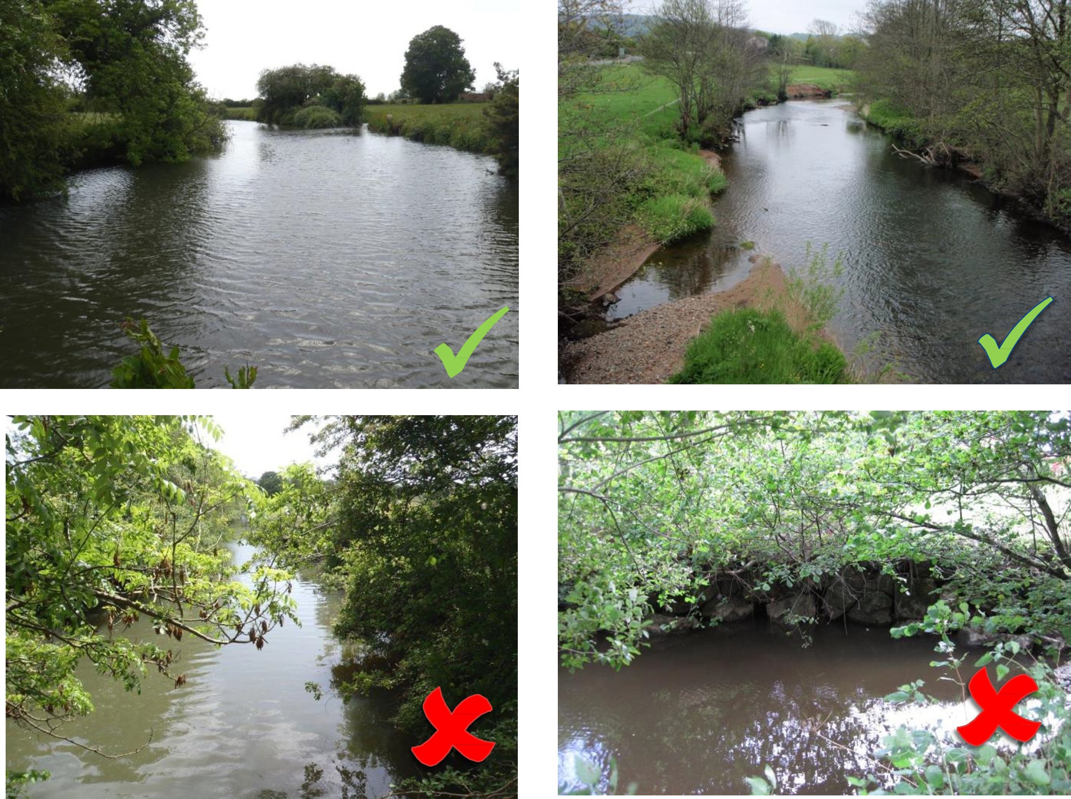
A PHOTOGRAPHIC RECORD OF THE SITE IS ESSENTIAL TO AID INTERPRETATION OF DATA, AND AS A RECORD OF THE SITE FOR FUTURE REFERENCE. At least two photos must be taken, and any others for clarification purposes. Sufficient photographs should be taken to illustrate the general character of the site. In more inaccessible sites it may be necessary to seek a vantage point that will provide the most comprehensive view. It may be necessary to take more than two photographs to effectively illustrate general character. Avoid taking photos directly into the sun.
Photographs of channel modifications and special features should also be taken. It is essential that all ‘major’ structures are photographed to enable interpretation of potential impacts.
A good quality digital camera is recommended. If this is not possible, take photos using a smart phone. The quality of digital photographs required will depend upon their intended use.
For inclusion on the RHS database, a 1024x768-pixel picture with a standard JPEG compression (100-150kbyte) is required. For inclusion in printed documents, additional photographs at a higher resolution (e.g.2048x1536 TIFF or JPEG) are recommended. A camera with built-in coding facilities is ideal as this should ensure photos are accurately assigned to a site, in the field.
If you are unsure about an unusual or unfamiliar feature, take a photograph for reference and make accompanying notes. Enter the number of photographs taken in the box. Photographs that include, in the foreground, a chalk-board showing the site reference, will ensure photographs and site survey forms always correspond. Enter on the form the references used during survey to ensure the correct photographs are matched with the sites surveyed. It is the responsibility of the surveyor to check that the photographs and site numbers match.
Site surveyed from
For wide and deep rivers, surveys might only be able to be carried out from one bank only, although for best results each bank would need to be walked. The same applies for rivers flowing through gorges. For shallow rivers a survey can be carried out easily from both sides of the channel, or by accessing the watercourse. ! Be aware of health & safety issues. Insert a tick in one or more boxes to indicate where site has been surveyed from.