Introduction
Preamble
River Habitat Survey (RHS) is a method designed to characterise and assess, in broad terms, the physical structure of freshwater streams and rivers. The field survey element does not require specialist geomorphological or botanical expertise, but recognition of vegetation types and an understanding of basic geomorphological principles and processes are needed.
RHS is carried out along a standard 500m length of river channel. Observations are made at ten equally spaced spot-checks along the channel, whilst information on valley form and land-use in the river corridor provides additional context.
The underlying need for any observational method such as RHS is confidence in the survey data. This means consistent recording of features by competent, well-trained, and accredited/certified surveyors as well as checks on subsequent data-entry into the computer database.
The field survey has been designed, tested and improved as a result of extensive use on rivers in the UK since 1994. The 2003 version represents the first major overhaul of the form design, revision of some component elements, and updating of the guidance manual, since 1997. The major differences between the 1997 and 2003 versions are summarised in Appendix 3.
Improvements in the design of the form and the supporting guidance have been necessary to remedy weaknesses in the consistency of recording.
The 2003 version addresses a number of these weaknesses by:
• providing more comprehensive definitions and guidance;
• including a greatly expanded photographic section;
• using a more user-friendly ‘icon’ system that highlights difficult features, health and safety issues and rare features, all of which need particular attention;
• introducing more stringent requirements for recording grid references and photographic information;
• introducing a mandatory health and safety risk assessment component;
• including a logical cross-check list to help minimise the chances of incomplete recording.
The importance of consistent recording, and also completing all elements of the survey form, is paramount. Incomplete forms, and those with inadequate details of site location or photographic evidence, will not be acceptable, and not entered onto the RHS database. There is an underlying principle that any unusual feature, or any aspect which a surveyor is uncertain about, should be recorded as a special note and a photograph taken to provide supporting evidence whenever possible.
Surveyor accreditation is needed for data to be entered onto the RHS database. This means surveyors attending a training course using the 2003 version, and passing an accreditation test.
The RHS database contains field observations, map-derived information and photographs from more than 4600 RHS baseline survey sites visited in 1994-96 and over 12,000 subsequent surveys. The 1994- 96 baseline network comprised a geographically representative cross-section of streams and rivers, selected on a stratified random basis, with the 10km grid squares of the Ordnance Survey as a sampling framework.
An overview of the physical condition of streams and rivers in the UK and Isle of Man was published in 1981, using the baseline data.
Since then, surveys have been used for a number of purposes, including:
- determining the catchment characteristics of several rivers in the UK;
- identifying the attributes of known top quality ‘benchmark’ sites;
- investigating possible species–habitat relationships;
- providing input to environmental impact assessment.
An educational CD-ROM has also been produced, using a simplified version of the RHS database.
RHS has also been tested in other European countries such as Finland, France, Austria, Portugal (Madeira), Italy and Slovenia with a view to adapting the survey for local conditions. Cross-comparison between RHS and other methods for surveying river hydromorphology in Europe has also been carried out, with a view to producing standard guidance on techniques for assessing the physical characteristics of watercourses.
The European Water Framework Directive has had a major influence in the development of RHS. Indeed, the prototype of the survey was developed in anticipation of the requirements of such a Directive as long ago as 1992.
The uses and sampling strategy for RHS depend on the purpose of gathering the survey information. Given its primary objective of context-setting, RHS can be used in general surveillance as well as site specific surveys. What it cannot do, and never was intended to do, is to provide the level of detail needed for specialised survey work for specific plant and animal groups. Nevertheless, RHS can provide a consistent framework within which aquatic macro-invertebrate, macrophyte, fish and geomorphological surveys can be set.
Although RHS conforms with the basic requirements for the draft guidance standard on assessing the hydromorphological characteristics of rivers, additional information on floodplain features and hydrology is also required for full compliance.
RHS also helps to provide information on river structure, vegetation character and land-use required for SERCON (System for Evaluating Rivers for Conservation), an assessment system that has scoring systems for several attributes in relation to determining the nature conservation value of rivers.
Scope of the manual
Guidance is provided on the fieldwork survey element of the core RHS method only. It does not cover map-based information gathering or the collection of additional information by certified surveyors following the survey.
The manual does not detail how to undertake preparatory work prior to a survey, gaining landowner permission, or how to link RHS to other surveys that may be carried out in tandem with RHS. All these aspects need to be planned and agreed between the commissioning organisation and the surveyor well before fieldwork is carried out.
The contents of the guidance are linked to the sequence of questions on the 2021 Survey form and are largely self-explanatory. Special icons are used to highlight issues requiring particular attention, such as when health and safety issues may be of special significance, features that are particularly rare in the UK, and where photos or videos help to illustrate features.
Essential equipment for undertaking RHS field surveys includes (see photos below):
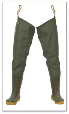
- waterproofs (thigh waders preferred)
- survey forms in a waterproof document holder;
- laminated mini-manual and spot-check key;
- a 2m ranging-pole;
- an electronic laser range-finder;
- a camera (smart phone);
- a 360 camera
- a global positioning system for recording geographic coordinates or alternatively a smart phone.


If the planned means of communication is by mobile phone, it is important to check that there is an adequate signal in the area being surveyed.
Health and safety
It is imperative that all surveys are conducted in conditions which are safe for surveyors. A health and safety risk assessment is an integral part of the survey and the form must be completed before embarking on the survey, and attached with the completed survey forms. An adequate Lone Working Guidance must be followed and surveyors must never put themselves in a position in which they are not in control. In areas of high risk, it is strongly recommended that a team of two undertakes a survey. Not starting a survey when the risk is too high should be the principle that applies throughout and surveyors should also be prepared to abandon a survey if conditions change and make it unsafe to continue.
Access and permissions
Whenever practicable, permission from landowners and occupiers should be obtained before surveys are carried out. This is not always feasible or possible, so if challenged cRHS surveyors should be polite, courteous and provide an explanation of what they are doing and why, and on whose authority. In some instances, this may mean having to return to do the survey if the landowner requires further clarification as to the purpose of the work. Identification must be carried by surveyors at all times. Surveyors should comply with disinfection requests from landowners. Surveyors can offer to provide information to landowners if they are interested in receiving it.
Preparatory work
Experience suggests that some RHS surveyors, no matter how experienced, can still overlook channel modifications. It is therefore recommended that some preparatory briefing is undertaken before visiting the site. For example, looking at the river shape and river name on a map will provide clues as to whether the watercourse has undergone historical channel management. Documentation of past flood defence works is also a source of invaluable information. Such information will help provide context for site characterisation, but should NOT over-ride field observations.
The survey form
The RHS survey form is four pages long and is accompanied by a separate manual with definitions and photo examples. The health and safety form is integral to the survey and should be attached to the RHS form. It is recommended that a clipboard or “Weather-writer” is used as well as a waterproof laminated version of mini-manual taken into the field at all times.
Surveyors are required to record the presence, absence, and in some cases the number or extent, of specific features. Four basic types of records are made:
- counting the number of certain features within the whole 500m site (e.g. artificial features);
- ticking boxes (✓) to indicate whether a feature is absent, present or extensive;
- entering a two-letter acronym for features in the spot-check section;
- taking measurements of the channel such as height, width and depth.
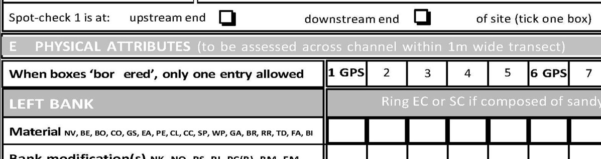
Where there is a choice of features to be scored, but only a single entry is allowed, boxes on the survey form are either ‘shadowed’ (❏) or have bold edges (see left bank material example below).
General site and surveyor information
Information about the surveyor, general site characteristics and details about when and how the survey has been undertaken are entered in Section A and B on Page 1. For most accurate recording, it is best to survey from both the river and the bank, but the overriding importance of health and safety issues will determine precisely how the survey is undertaken. Most of the information in both Sections A and B of the form can be completed on arrival at a site, or at the end of the survey, as appropriate. The total number (including zero) of artificial features such as weirs and bridges is recorded in Section C. This is best done by keeping a cumulative record of the number of these individual features when walking between spot-checks, and then tallying them up on completion of the survey. Please remember to take photographs of any structure recorded.
Suitable conditions and season
RHS should never be carried out during flood (spate) flows because there are major safety risks involved. High water levels and turbidity will also obscure many of the features RHS is designed to record and give a false impression of flow-types compared with those expected under dry-weather conditions. If a prolonged period of heavy rain occurs, a survey should be delayed until both water level and clarity, return to acceptable levels. In some lowland UK rivers abundant growth by emergent and bankside vegetation in summer will obscure some channel features. Surveys during this period should be avoided: May and June are considered the most suitable months. Upland rivers with little or no emergent vegetation are suitable for surveying over a much longer season. If, for special reasons, surveys have to be carried out during non-optimal moths, interpretation of the results will need to take full account of seasonal aquatic and bankside vegetation growth. Likewise, in countries with different climatic conditions from the UK, surveys should be ideally carried out when aquatic vegetation growth is evident, but not excessive, and water levels are not high.
Quality control
Each RHS form must be checked for completeness. An extra two minutes for quality control at the end of each survey is invaluable, because incomplete forms will be returned and a re-survey may be needed. if using paper survey forms, it is important that completed RHS forms are legible, and the pages stapled together with a site reference clearly marked on all pages. If an extra sheet is used for additional observations, make sure this is similarly marked and firmly attached. Of equal importance is the need to clearly label all photographs, and ensure they match the references given on page 1 of the form. Data input software exists for RHS, that also enables the calculation of various indices such as the Habitat Modification Score (HMS) and Habitat Quality Assessment Score (HQA). Please refer to the RHS website www.riverhabitatsurvey.org
Contact for enquiries
Queries and further information on this manual should be addressed to:
The RRC, 2nd Floor Ziggurat, Vincent Building (B52a), Cranfield University, Cranfield, Bedfordshire, MK43 0AL
+44 1234 752979