The RHS Toolbox version 2.2 is a major update of the RHS Toolbox. It includes the Citizen River Habitat Survey and links to the RHS/cRHS online platform, enabling data, photos, videos and 360 photos sharing. This new version of the software was developed with the support of Natural Resources Wales and in collaboration with the River Restoration Centre.
Citizen River Habitat Survey support
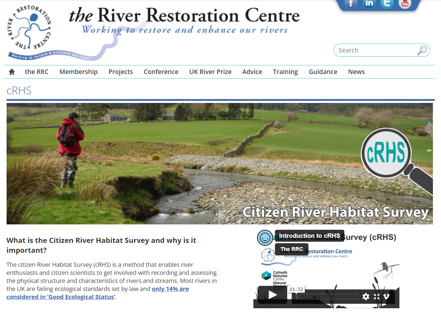
The Citizen River Habitat Survey (cRHS) was developed in 2022 alongside a web platform with a map and a data repository. The cRHS is a simplified version of the RHS that was designed for non-specialist and volunteers so that, with reduced training, they could collect 75% of an RHS form data alongside videos of every spot-checks and, optionally, 360 photos along the sites. Using the photos and videos, more expert RHS surveyors can then complete the form to bring it to a standard where it is comparable to a full RHS so that quality indices can be computed and compared to other RHS sites. This process is done in collaboration with the Citizen surveyors therefore creating a learning cycle where less experienced surveyors learn from more experts one and also share their local knowledge. More information can be found on the Citizen RHS website: https://www.therrc.co.uk/crhs.
Sharing data online
An online platform for cRHS material and cRHS and RHS data was developed with the support of Natural Resources Wales and in collaboration with the River Restoration Centre. The online platform features access to online learning material for Citizen RHS, a free online cRHS course, forms, manual and a map of existing RHS and cRHS sites.
Using the RHSToolbox, you will now be able to add georeferenced photos and videos as well as 360 photos that you can transfer to an online data repository. This can be done through the export menu.

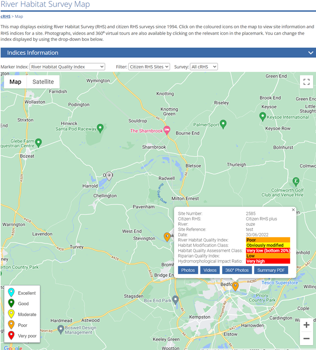
The RHS Toolbox will transfer RHS and cRHS data online, alongside photos and videos. 360 photos will be turned into a virtual walk and a summary report will be produced included a data analysis section. The survey location will be displayed on the RHS/cRHS map online and host links to photos, videos, 360 virtual tours and summary data.

Data analysis form and report sections
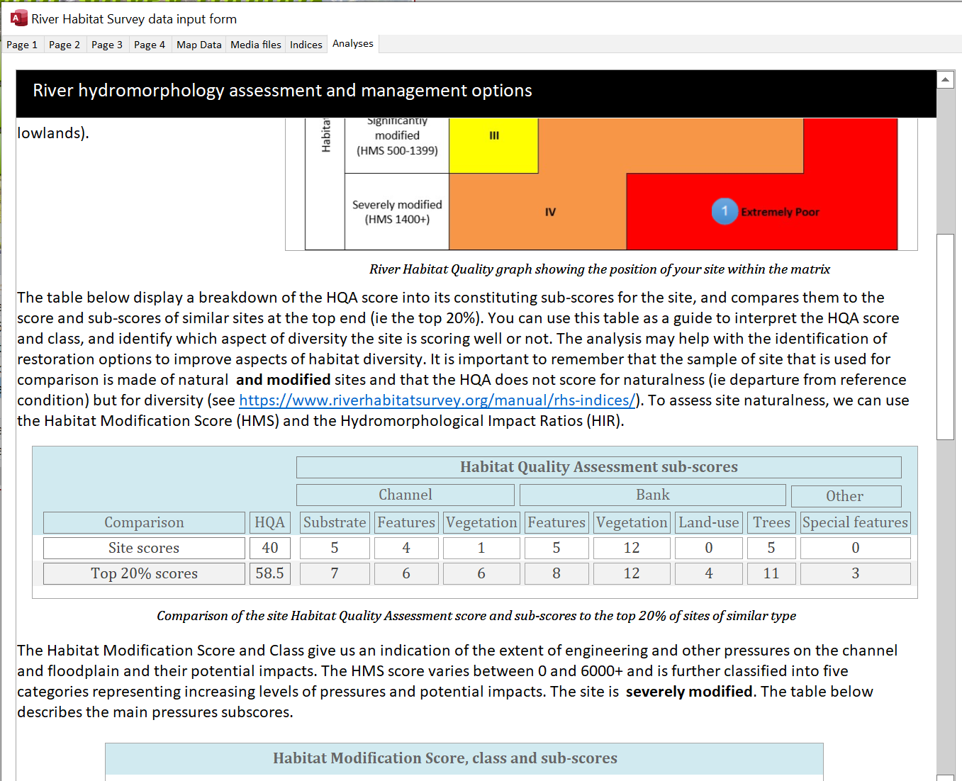
We added a data analysis tab to the RHS and cRHS forms. The tab presents a short report that is also included in the survey printout. The section text is activated when all indices have been derived and, importantly, a River Habitat Quality class was produced. The report features a simple analysis of the survey habitat quality indices. It also points potential modifications such as channel resectioning using information on width and depth. Some general directions for channel management are suggested with links to the RRC manual of techniques and case study web pages.
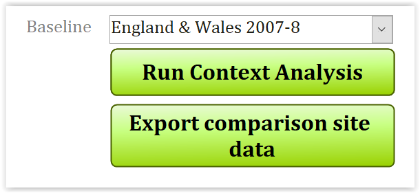
Improved context analysis
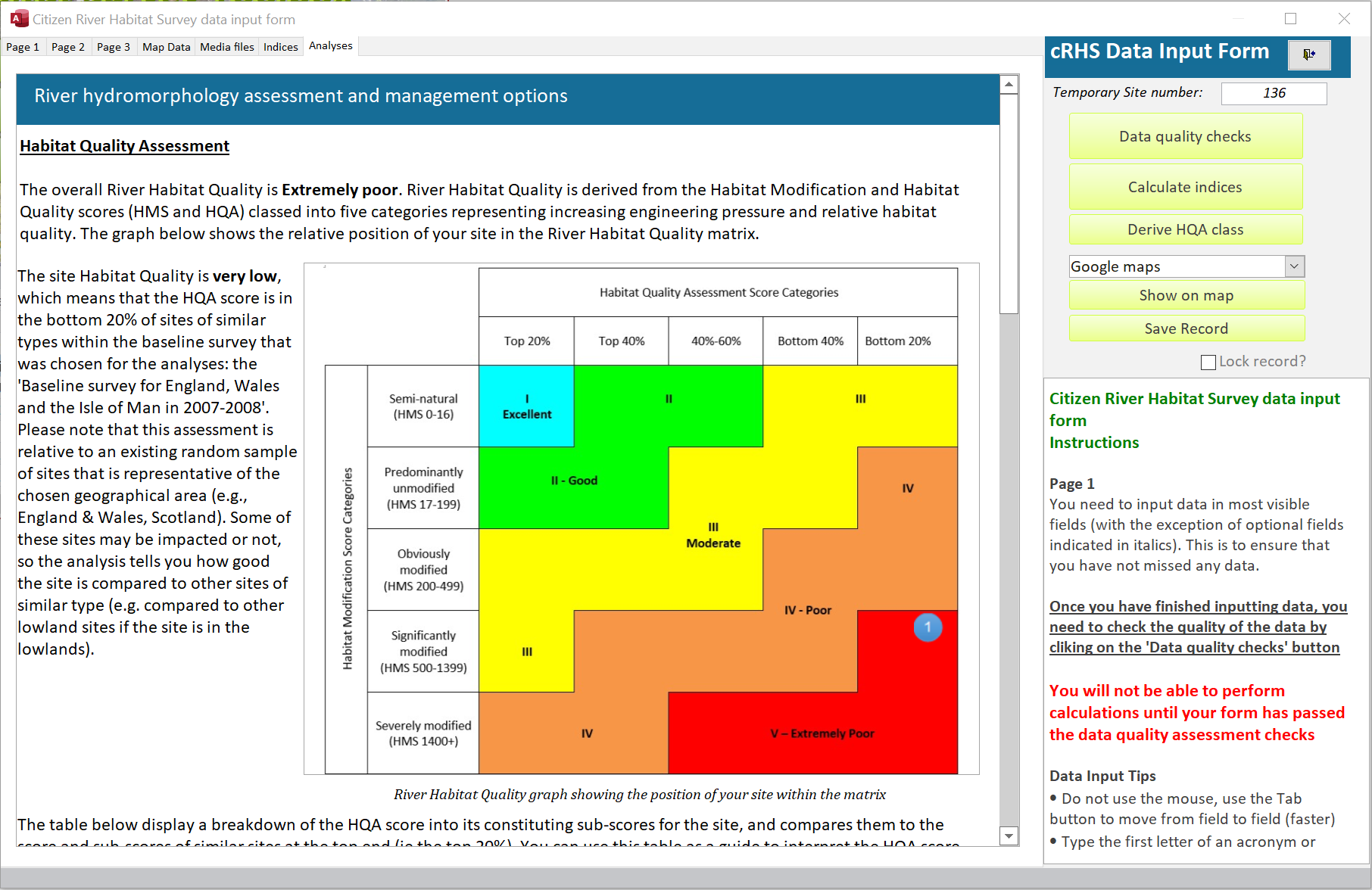
The context analysis enables the comparison of your survey Habitat Quality Analysis index (HQA) to that of a sample of RHS sites from the national reference network (see below). The module now features some statistics on the sample of sites that were used to comparison that did not feature in the previous version. On top of having statistics for sites with moderate HQA score, the form also displays HQA score and sub-scores for the top 20% of sites in the sample used for comparison. That means you can compare your survey results to that of high quality sites and observe differences.
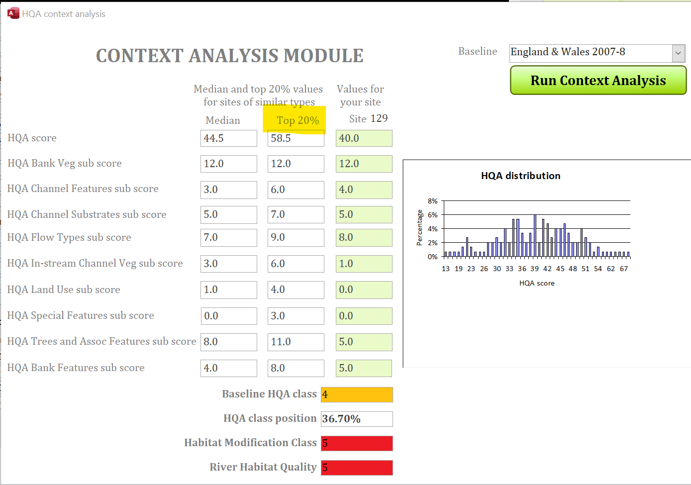
The statistics are tabulated and feature in the data analysis form and report section of the RHS and cRHS forms.
Import of cRHS Android app data
The RHS Toolbox can import data from the cRHS Android app. The import will collect hyperlinks and metadata (ie latitude, longitude etc) for all photos and videos and list them in the 'Media' tab.
Previous versions update history
Version 1.5
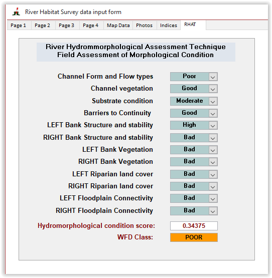
River Hydromorphology Assessment Technique (RHAT) scoring form
The River Hydromorphology Assessment Technique (RHAT) was developed in Northern Ireland by the Department of Environment to assess the hydromorphological condition of rivers for the Water Framework Directive (WFD). The field survey methodology was based on RHS and contains the same amount of information as a standard survey. The main differences are the width of spot-checks, which in RHAT are 50 m wide. The RHAT survey methodology also allows for partial surveys of the stream as the final scoring system does not rely on recorded data for its implementation.
The field assessment of morphological condition as part of RHAT is carried out in the field using expert opinion. Eight attributes representing bank and channel features and geomorphological functions are assessed on the scale of 0 (bad) to 4 (high) for their condition. Guidance on assessing condition is provided in the RHAT manual.
As the RHAT condition assessment is not calculated directly from survey data, it is possible to derive the score for a standard RHS. The RHAT condition assessment sheet was therefore added to the RHS toolbox as an additional option whilst doing surveys
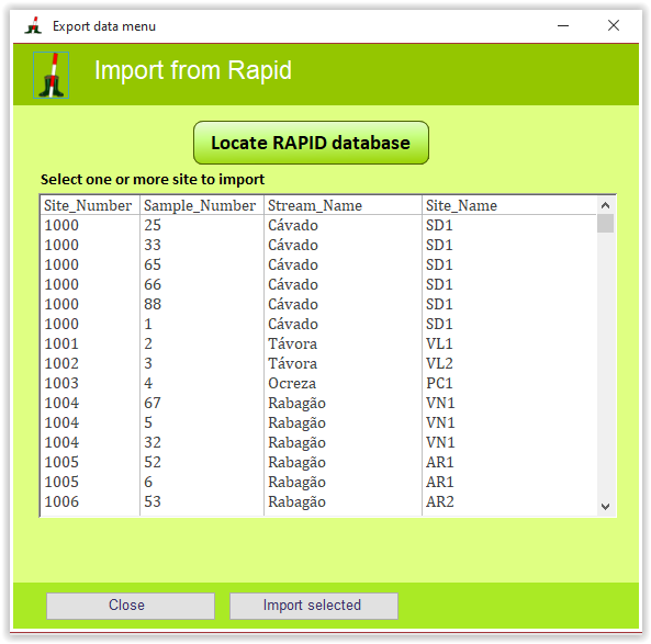
RAPID data import
RAPID is an application developed by the Centre for Ecology and Hydrology in the United Kingdom to input and process RHS data.
You can now import data from the RAPID database version 2 and 3 using the import button.
Version 1.4
Automated map data extraction for sites in England, Wales and Scotland (only available to licenced users)
To be able to run a context analysis with the RHS Toolbox, you need to derive altitude, slope, distance to source and height of source to calculate the PCA score for your site that will be used to select sites of similar types (see Jeffers, 1998 in References and Context analysis).
Using the RHS Toolbox, you can now automatically extract this information using a database of previously derived point on the river network. A form will display all nearby points using the mid-site grid reference and you will be able to map them to decide which one to choose for your site (see below). This feature is only available to licenced users and is not available to trial versions.
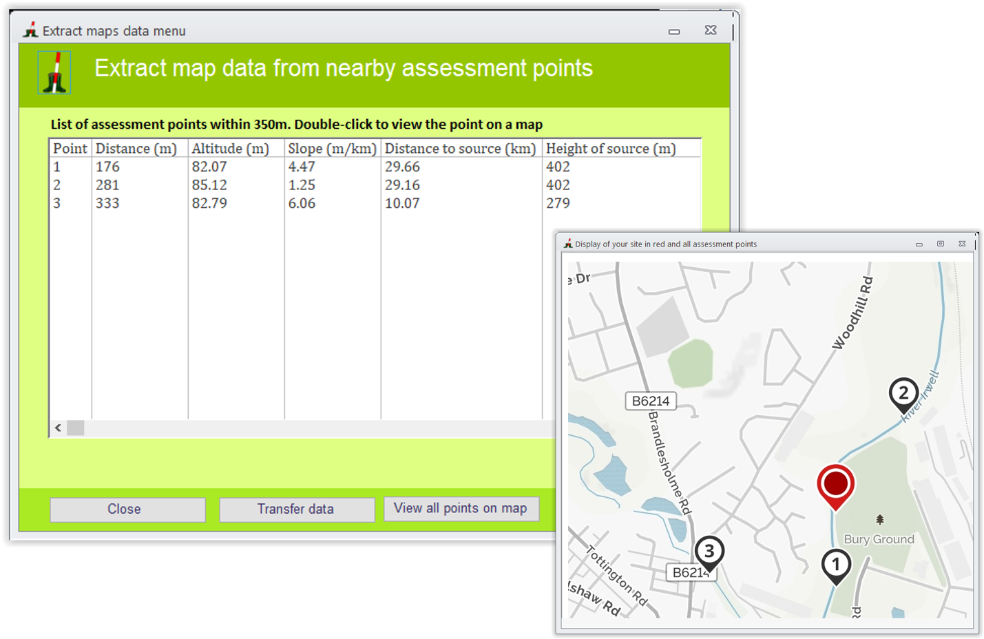
The process will not only extract data on for PCA score calculation but also background information on geology, sinuosity, typology using the Jeffers types (1998) and also predictions for four hydromorphological indices (Indices) in semi-natural conditions. This will enable the calculation of Hydromorphological Impact Ratio indices for your site to assess departure from semi-natural conditions (see below).
New indices
A series of indices and fields have been added to the interface.
Hydromorphological Impact Ratios
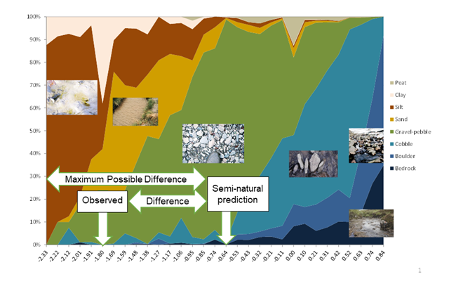
Provided your site is located in Great Britain, the software will extract predictions for four hydromorphological indices (Appendix 2) at semi-natural conditions (the 'expected' column in the figure below). These indices were derived as part of a research project (Naura et al ms). The RHS Toolbox will then calculate Hydromorphological Impact Ratios (HIR) for each index.
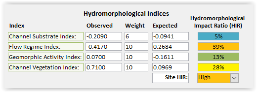
HIRs represent the level of departure from semi-natural condition (or impact) for each index compared to the maximum level of departure (or maximum possible impact) that could be expected (see figure below). The HIRs are expressed as percentage values from 0% (no impact) to 100% (maximum possible impact). The site HIR represents the maximum possible impact for any of the four indices categorised into 12.5% classes:
Agricultural fine sediment load and potential risk to biota
Provided your site is located in Great Britain, the software will extract information on agricultural fine sediment delivery to your site in tonnes per year and derive a series of indices representing Agricultural Sediment Load (ASL), Fine Sediment Accumulation (FSA) and overall Agricultural Sediment Risk (ASR). These indices were derived as part of research for the UK government and published in 2016 (Naura et al 2016).
Total agricultural fine sediment delivery represent all fine sediments transported from upstream in the water column and local sediment delivery through run-off and tributary inputs. The data are derived using modelling but can be entered by hand by the user.
Local agricultural fine sediment delivery represent all fine sediments delivered through run-off and tributary inputs.
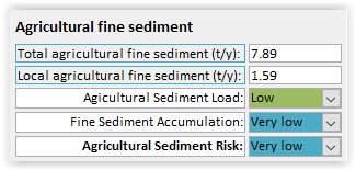
The Fine Sediment Accumulation index is derived directly from your RHS site spot-check data for channel substrate. Sites will be categorised according to the number of spot-checks with silt, sand or clay as:
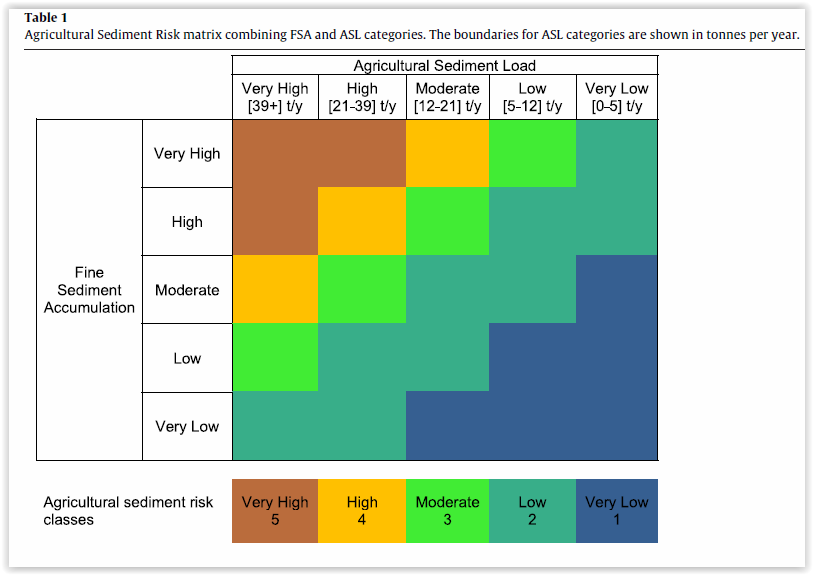
The ASR combines the FSA and ASL using a matrix
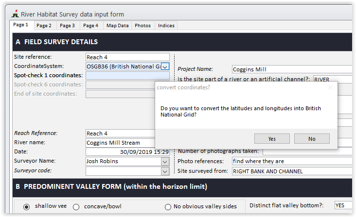
Convert latitude/longitude to British Grid References
You can now convert latitudes and longitudes into NGR. Simply select the OSGB36 grid reference system in page 1 and it will offer you to do the conversion.
A similar conversion to Irish NGR is not yet possible as there is a bug in the library file provided for which we are waiting for a fix.
Importing data from RAPID
It is now possible to import data from the RAPID version 2 or 3 databases.
Sharing your data on a network drive (only available for site licences)
It is now possible to share the back-end user database on a network drive (see Network drive). To do so, you need a network licence.
Bug fixing and code improvements
A series of bugs have been fixed and some improvements to the software interface and code were made.
Version 1.3
Version 1.2
Data import from the new Android RHS mobile app
The RHS Toolbox can now automatically import data an photo links from the newly developed RHS mobile Android app.The switchboard features an import button that automates the process of inputting the data from the RHS mobile export file as well as indexing photos and other additional files.
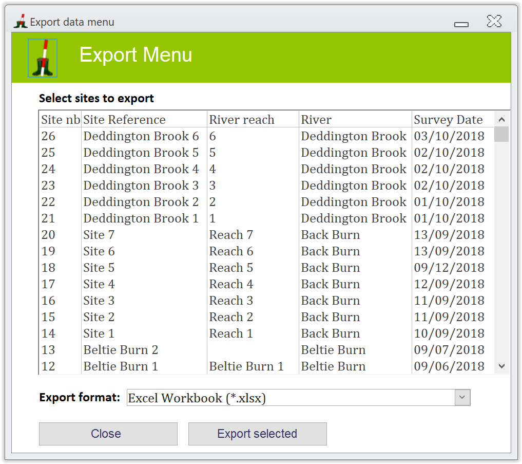
Data export to multiple formats
You can now export RHS data from single or multiple sites to Excel, rtf, txt, pdf or html formats.
Bug fixing and code improvements
A series of bugs on the calculation of scores have been fixed. We recommend that you re-run index score calculation for all your previous files.
The QA code and procedures were also improved amd new procedures were added. The information window now stays on after the QA and can be opened separately as a popup window by double-clicking it.
Context analysis with export function
When running a context analysis, the software now stores median values for HQA scores in the database. You can access these scores by exporting the data using the new export functionality.
Also, the software now enables users to export the data from the 150 sites that were used for the derivation of HQA class to Excel so that additional analyses can be performed.
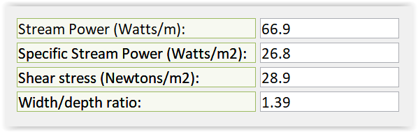
New indices
A series of indices and fields have been added to the interface. Provided you input Qmed discharge and measurement data are adequate (i.e. a bankfull has been identified), the software will calculate stream power and shear stress values as well as width/depth ratio..
A new Riparian Quality Index was added to the index calculation procedure. Th index assesses riparian quality using measures of complexity, naturalness and continuity.
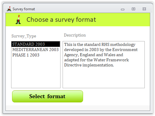
New survey formats
The RHS Toolbox now offers to input data using three survey formats:
The three format are described in the survey format menu (see below)